
Residents of the Western Cape, Northern Cape, and Free State should brace for icy temperatures and severe weather as an intense cold front approaches. The South African Weather Service warns of hazardous conditions, including heavy rainfall and gale-force winds.
Image: Armand Hough/Independent Media
Residents living in the Western Cape, Northern Cape and Free State will wake up to icy temperatures as an intense cold front is expected to make landfall from Wednesday.
"The public and small stock farmers are advised that icy, wet and windy conditions with heavy rainfall, strong interior winds and gale force coastal winds, very rough to high seas and light snowfall on the high-ground can be expected," the South African Weather Service (Saws) said.
Meanwhile, extremely high fire danger conditions are expected over the eastern parts of Northern Cape, the western parts of both North West and Free State, the Beaufort West municipality of Western Cape as well as most places in the western parts of the Eastern Cape.
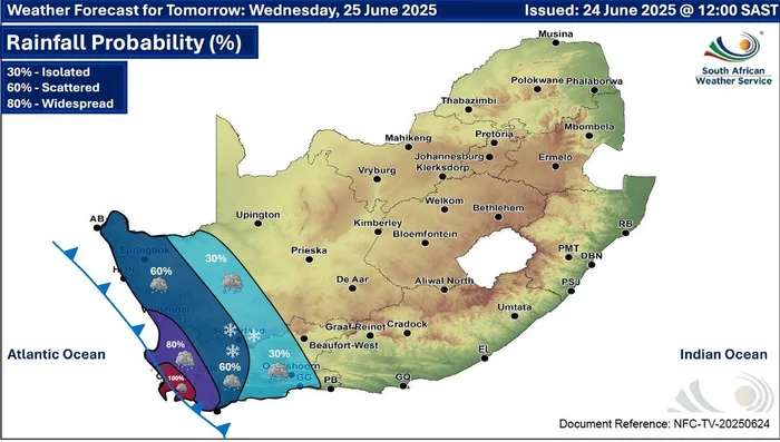
Wednesday's weather alert
Image: SAWS
Yellow Level 4 warning: Damaging waves resulting in damage to coastal infrastructure and disruption to beachfront activities is expected along the coast between Alexander Bay and Cape Agulhas from Wednesday evening, spreading to Plettenberg Bay by Thursday.
Yellow Level 2 warning: Damaging coastal winds leading to difficulty in navigation at sea and localised disruption to small ports and coastal towns are expected between Lambert's Bay and Cape Agulhas on Wednesday, spreading to Plettenberg Bay by Thursday.
Yellow level 2 warning: Damaging interior winds leading to localised problems for high-sided vehicles on prone routes and some transport services affected by wind are expected over the western and northern parts of the Western Cape, Northern Cape, as well as the western parts of the North West province and Free State.
Yellow level 2 warning: Disruptive rainfall leading to localised flooding of susceptible formal and informal settlements or roads, and low-lying areas over Cederberg, City of Cape Town, Cape Winelands, and the western parts of the Overberg District (Western Cape).
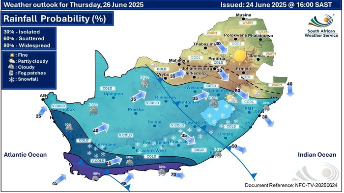
Most of the country will experience the icy weather from the cold front with snow predicted in some areas.
Image: SAWS
For Thursday and Friday, the forecaster said it will be partly cloudy over the central and western parts of the country with isolated to scattered rain and showers along the south coast. It will also be fine and cold in other parts.
IOL